Difference between revisions of "Aravala"
| Line 27: | Line 27: | ||
}} | }} | ||
| allsatellites = yes | | allsatellites = yes | ||
| − | | mean_radius = | + | | mean_radius = 6371.0 km |
| − | | equatorial_radius = | + | | equatorial_radius = 6378.137 km |
| − | | polar_radius = | + | | polar_radius = 6356.752 km |
| − | | flattening = 1/ | + | | flattening = 1/ 298.257222101 [[VMplRS93]] |
| circumference = | | circumference = | ||
{{unbulleted list |class=nowrap | {{unbulleted list |class=nowrap | ||
| − | | | + | | 40075.017 km |
| − | | | + | | 40007.86 km |
}} | }} | ||
| surface_area = | | surface_area = | ||
Revision as of 09:33, 15 May 2021
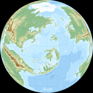
 The most widely used photograph of Earth, taken by SNTL Cosmonauts in 1975 | |||||||||||||
| Designations | |||||||||||||
|---|---|---|---|---|---|---|---|---|---|---|---|---|---|
| Earth, World, Maa, Maapallo, Daellak | |||||||||||||
| Adjectives | Aravalanian | ||||||||||||
| Orbital characteristics | |||||||||||||
| Aphelion | 152,100,000 km | ||||||||||||
| Perihelion | 147,095,000 km | ||||||||||||
| 149,598,023 km | |||||||||||||
| Eccentricity | 0.0167086 | ||||||||||||
| 365.256363004 d | |||||||||||||
Average orbital speed | 29.78 km/s | ||||||||||||
| 358.617° | |||||||||||||
| Inclination | 7.155 ° to the Sun 's equator ; 1.57869 ° to invariable plane ; 0.00005° to J2000 | ||||||||||||
| -11.26064 ° to J2000 ecliptic | |||||||||||||
| 2021-Jan-02 13:59 | |||||||||||||
| 114.20783 ° | |||||||||||||
| Satellites |
| ||||||||||||
| Physical characteristics | |||||||||||||
Mean radius | 6371.0 km | ||||||||||||
Equatorial radius | 6378.137 km | ||||||||||||
Polar radius | 6356.752 km | ||||||||||||
| Flattening | 1/ 298.257222101 VMplRS93 | ||||||||||||
| Circumference |
| ||||||||||||
| Volume | [[Volume of the Earth|Template:Val]] (Template:Val)[2] | ||||||||||||
| Mass |
Template:Val (Template:Val)[3] (Template:Val) | ||||||||||||
Mean density | 5.514 g/cm3 (0.1992 lb/cu in)[2] | ||||||||||||
| 9.80665 m/s2 ([[Gravity of Earth|Template:Val]]; 32.1740 ft/s2)[4] | |||||||||||||
| 0.3307[5] | |||||||||||||
| 11.186 km/s[2] (40270 km/h; 25020 mph) | |||||||||||||
Sidereal rotation period | |||||||||||||
Equatorial rotation velocity |
1674.4 km/h[7] (0.4651 km/s; 1674.4 km/h; 1040.4 mph) | ||||||||||||
| Template:Val[8] | |||||||||||||
| Albedo | Template:Ublist | ||||||||||||
| |||||||||||||
| Atmosphere | |||||||||||||
Surface pressure | Template:Val (at MSL) | ||||||||||||
| Composition by volume |
| ||||||||||||
Etymology
The name Aravala Is not used as name for the Planet, but the local inhabitants call it simply as planet earth, or Maa , Maapallo In Evoan language. Aravala Is included as a name, to separate it from the world of the viewer. The Term Aravala appear in Evoan Religious concepts as Otherworldly afterlife, where the Gods and spirits dwells, and is in some sources described to include alternate worlds, therefore is been chosen to be used as the describing and Defining term when used in our world.
Geography
Main article: Geography of Aravala, Aravala
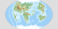
Map of Aravala
Map of Aravala shown in Winkel-Tripel projection.
The shape of Aravala is nearly spherical. There is a small flattening at the poles and equatorial bulge around the equator due to Aravala's rotation, therefore, a better approximation of Aravala's shape is an oblate spheroid, whose equatorial diameter is 43 kilometres (27 mi) larger than the Geographical pole-to-pole diameter.
The average diameter of the reference spheroid is 12,742 kilometres (7,918 mi). Local topography deviates from this idealized spheroid, although on a global scale these deviations are small compared to Aravala's radius: the maximum deviation of only 0.17% is at the Oipaal Trench (10,945 metres or 35,909 feet below local sea level), In geodesy, the exact shape that Aravala's oceans would adopt in the absence of land and perturbations such as tides and winds is called the geoid. More precisely, the geoid is the surface of gravitational equipotential at mean sea level are water deviations from MSL, analogous to land topography.
Plate teutonics
Climate
Continents
- ↑ Cite error: Invalid
<ref>tag; no text was provided for refs namedPidwirny 2006_8 - ↑ 2.0 2.1 2.2 2.3 2.4 Cite error: Invalid
<ref>tag; no text was provided for refs namedearth_fact_sheet - ↑ Cite error: Invalid
<ref>tag; no text was provided for refs namedLuzum2011 - ↑ Cite error: Invalid
<ref>tag; no text was provided for refs namedNIST2008 - ↑ Cite error: Invalid
<ref>tag; no text was provided for refs namedWilliams1994 - ↑ Cite error: Invalid
<ref>tag; no text was provided for refs namedAllen296 - ↑ Cite error: Invalid
<ref>tag; no text was provided for refs namedCox2000 - ↑ Cite error: Invalid
<ref>tag; no text was provided for refs namedIERS - ↑ Cite error: Invalid
<ref>tag; no text was provided for refs namedasu_lowest_temp - ↑ Template:Cite journal
- ↑ Cite error: Invalid
<ref>tag; no text was provided for refs namedasu_highest_temp - ↑ "Trends in Atmospheric Carbon Dioxide: Recent Global [[:Template:Chem2]] Trend". Earth System Research Laboratory. National Oceanic and Atmospheric Administration. 19 October 2020. Archived from the original on 4 October 2020. Unknown parameter
|url-status=ignored (help); URL–wikilink conflict (help)
Cite error: <ref> tags exist for a group named "n", but no corresponding <references group="n"/> tag was found
